Gazing upon a volcanic eruption from Earth is a humbling experience, its raw power and fiery dance captivating and terrifying in equal measure. But witnessing this drama unfold from the vantage point of space adds a whole new dimension of awe and wonder. Satellite images captured by NASA’s Earth Observatory and by astronauts aboard the International Space Station reveal eruptions as mesmerizing celestial ballets, painting the inky blackness of space with streaks of molten rock, plumes of ash, and shockwaves that ripple across the atmosphere.
These satellite images unveil the hidden choreography of an eruption. Imagine a fiery fountain erupting from a crack in the planet’s crust, spewing incandescent lava that snakes across the land like molten rivers. Ash plumes billow upwards, their swirling tendrils reaching for the heavens, sometimes even breaching the stratosphere and casting long shadows across continents. The sheer scale of these events is breathtaking, with lava flows stretching for kilometers and ash clouds dwarfing entire landscapes.
These images (which allow you to zoom in if you click them) aren’t just visually stunning; they also provide invaluable scientific insights. By studying the temperature variations, gas composition, and ash dispersal patterns captured by satellites, scientists can better understand the inner workings of volcanoes, predict future eruptions, and mitigate their devastating effects. So, the next time you see a news report about a volcanic eruption, take a moment to imagine the spectacle unfolding above Earth, a mesmerizing display of nature’s power and beauty.
This looping video displays an umbrella cloud formed by the underwater eruption of the Hunga Tonga-Hunga Ha’apai volcano on Jan. 15, 2022. Images from the GOES-17 satellite captured the phenomenon, revealing crescent-shaped shock waves and lightning strikes. Credits: NASA Earth Observatory image by Joshua Stevens using GOES imagery courtesy of NOAA and NESDISu003c/strongu003e
In autumn 2023, eruption activity intensified at Russia’s Klyuchevskoy volcano on the Kamchatka Peninsula. The image below, captured by Landsat 8’s OLI (Operational Land Imager) on November 1, 2023, provides a close view of the lava flows and ash plume emerging from the volcano. Click image to enlarge and zoom in. Image credit: NASA Earth Observatory/Wanmei Liang and Lauren Dauphin
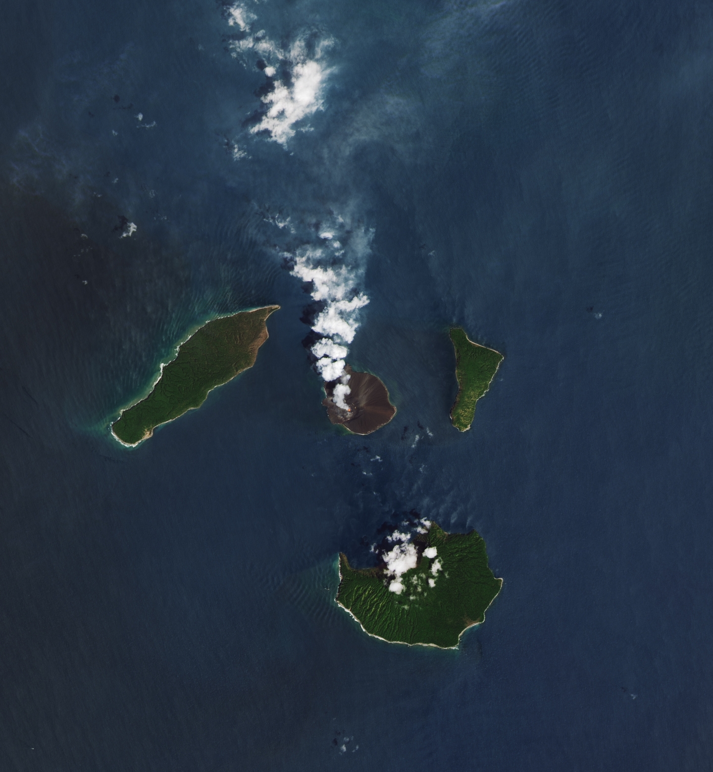
Anak Krakatau is a small volcanic island situated between Java and Sumatra. Despite its size, its frequent eruptions remind us of its significant and sometimes threatening force. On December 2, 2023, Landsat 8’s Operational Land Imager (OLI) captured an image showing a volcanic plume emanating from the island’s crater, with the red infrared signal indicating the presence of molten rock heat. Click image to enlarge and zoom in. Image credit: NASA Earth Observatory/Lauren Dauphin
Popocatépetl, Mexico’s most active volcano and second-highest peak, lies 70 kilometers southeast of Mexico City and 40 kilometers west of Puebla. It has been active for decades, characterized by continuous venting from the crater, periodic growth of lava domes, and explosive eruptions. On January 27, 2024, the OLI (Operational Land Imager) on Landsat 8 captured an image of one of the volcano’s recent periods of activity. Click image to enlarge and zoom in. Image credit: NASA Earth Observatory/Michala Garrison
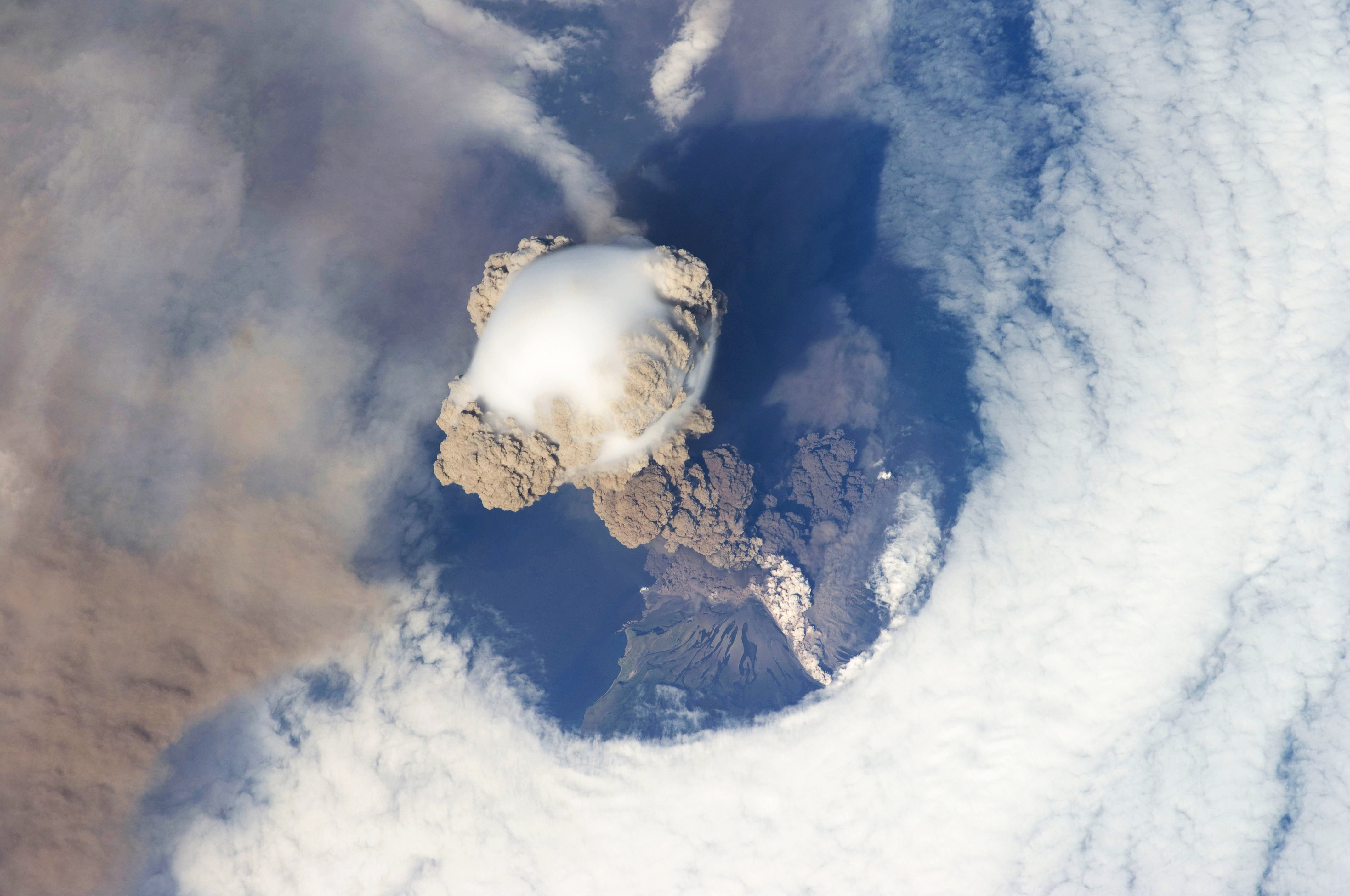
A fortunate orbit provided astronauts with a remarkable sight of Sarychev volcano in Russia’s Kuril Islands, northeast of Japan, during an early phase of eruption on June 12, 2009. Located on the northwestern end of Matua Island, Sarychev Peak stands as one of the most active volcanoes in the Kuril Island chain. Click image to enlarge and zoom in. Image credit: NASA
This animation, based on astronaut photography, offers a view of the ash and steam rising from the volcano.
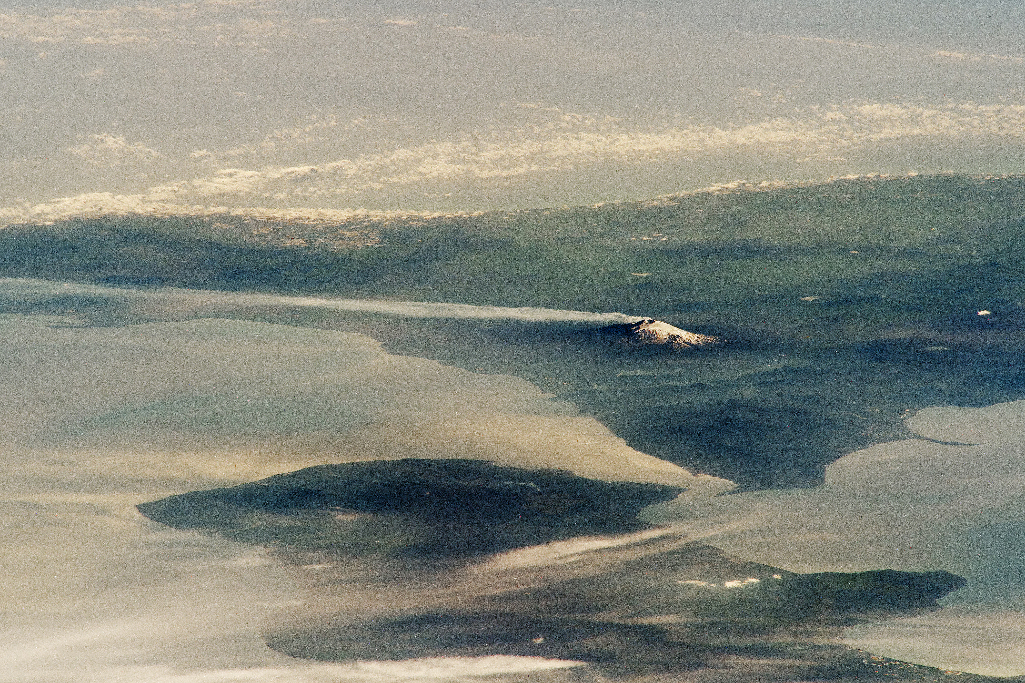
This oblique view of Mount Etna, Europe’s most active volcano, was captured by an External High-Definition Camera (EHDC) mounted on the exterior of the International Space Station, as it orbited over the Black Sea approximately 1448 kilometers (900 miles) from its location in Sicily, Italy. In this image, a slight plume drifts southeast from Etna (leftward in the view). Although taken in March 2023 during a non-eruptive phase, the volcano erupted as recently as August 2023. Click image to enlarge and zoom in. Image credit: NASA/JSC
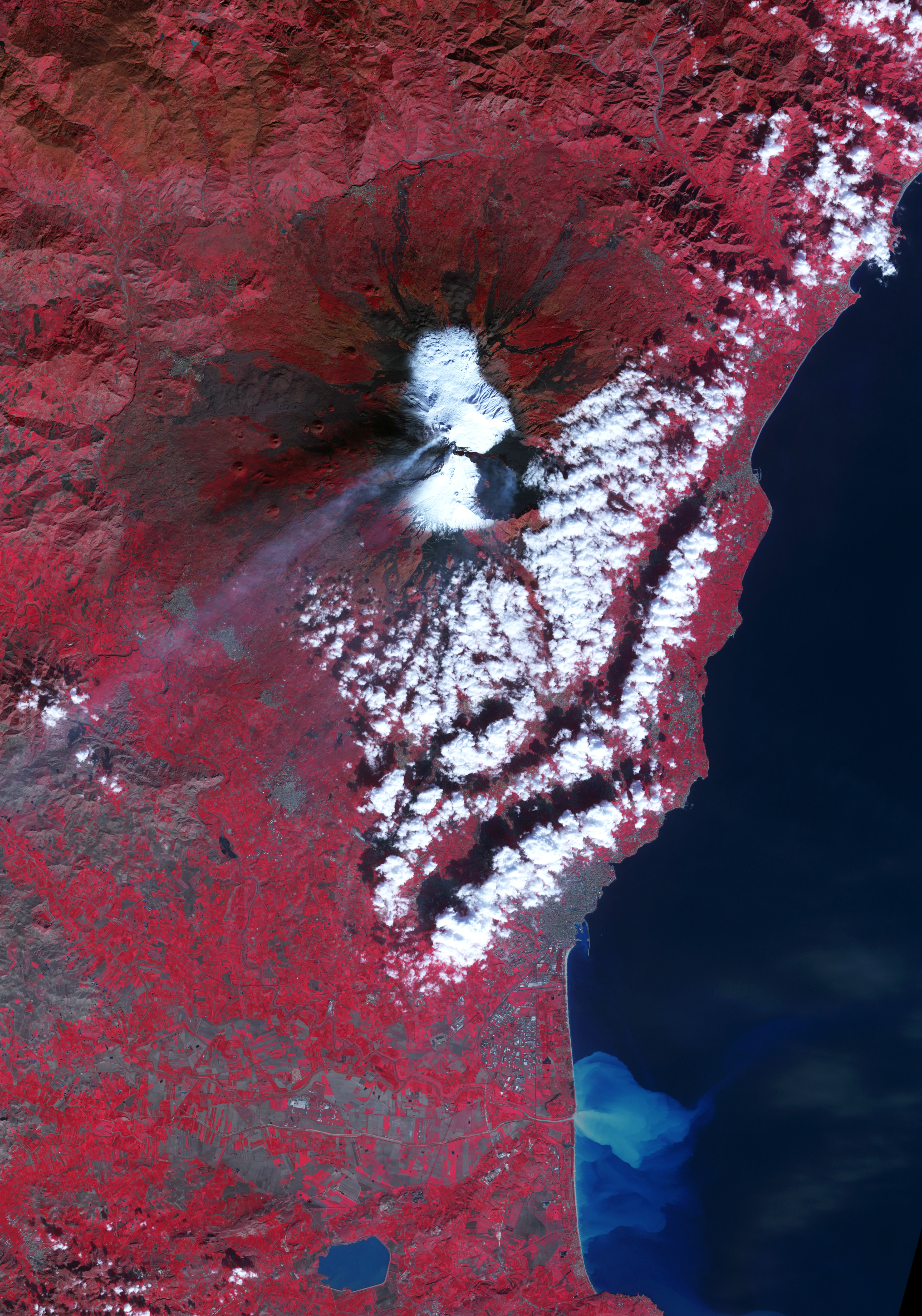
Lava flow on Mount Etna (click image to zoom in). On November 30, 2006, Mount Etna showcased ongoing activity with steam plumes rising from multiple vents. The most robust plume originated from the Northeast Crater, while a second, fainter one emerged from the Southeast Crater. Throughout much of 2006, Etna experienced frequent eruptive episodes, with late November focusing mainly on the Southeast Crater. The eruption featured continuous lava flows, explosions, rockfalls, steam emissions, and debris near the crater. Click image to enlarge and zoom in. Image credit: NASA/Jesse Allen
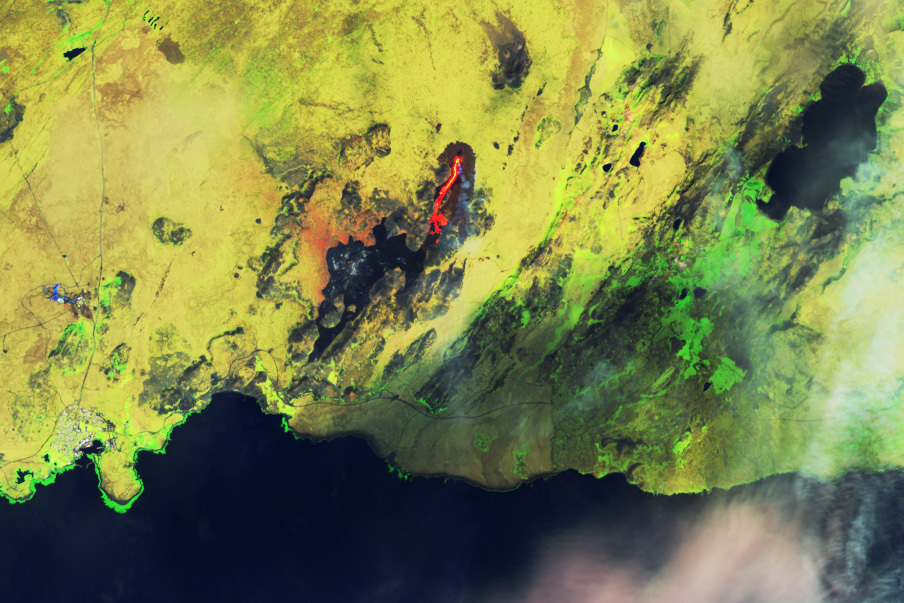
Lava started flowing from the Fagradalsfjall volcanic system in southwestern Iceland on July 10, 2023, marking its third consecutive summer of activity. The image, captured on July 17, 2023, by the Operational Land Imager-2 (OLI-2) on Landsat 9, utilizes visible and infrared light (bands 6-5-3) to differentiate the heat signature of the lava. Fresh lava flows, depicted in bright yellow and orange, contrast with cooled flows from prior eruptions, which appear black. Click image to enlarge and zoom in. Image credit: NASA Earth Observatory/Wanmei Liang
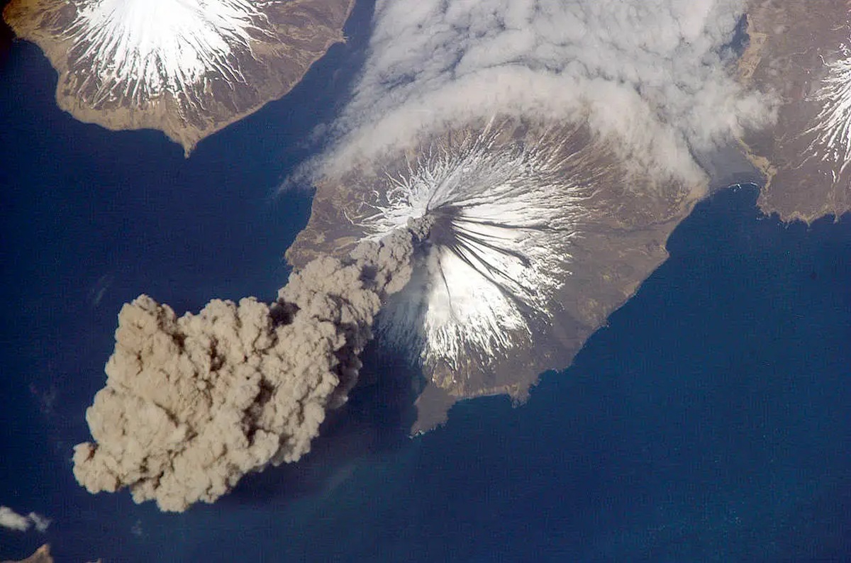
On May 23, 2006, Flight Engineer Jeff Williams of International Space Station (ISS) Expedition 13 contacted the Alaska Volcano Observatory (AVO) to report the emergence of an ash plume from the Cleveland Volcano. He captured this photograph shortly after the activity commenced. A fog bank (upper right) frequently appears around the Aleutian Islands. The occurrence was brief; two hours later, the plume had entirely separated from the volcano. According to the AVO, the ash cloud’s altitude might have reached up to 6,000 meters (20,000 feet) above sea level. Click image to enlarge and zoom in. Image credit: NASA
After over a year of calm, Nyamuragira volcano in the Democratic Republic of Congo erupted on November 6, 2011. Lava surged from a fissure on the volcano’s flank, flowing northward away from populated regions. Nyamuragira, a shield volcano, ranks among Africa’s most active. Click image to enlarge and zoom in. Image credit: NASA Earth Observatory/Jesse Allen
Lava flow on Nabro volcano on June 29, 2011. Located in the East African nation of Eritrea, Nabro erupted explosively on June 12, 2011, sending ash plumes over North Africa and the Middle East and releasing large amounts of sulfur dioxide. Flights in East Africa were disrupted due to the ash. The Eritrean government reported seven fatalities, with thousands affected in Eritrea and Ethiopia, although information from the region is limited. Click image to enlarge and zoom in. Image credit: NASA Earth Observatory/Robert Simmon
Another view of the Nerbo volcano’s eruption taken 5 days earlier, on June 24, 2011. This was one of the first detailed pictures of the erupting vent and lava flows, acquired by the Advanced Land Imager (ALI) aboard the Earth Observing-1 (EO-1) satellite. Click image to enlarge and zoom in. Image credit: NASA Earth Observatory/Robert Simmon
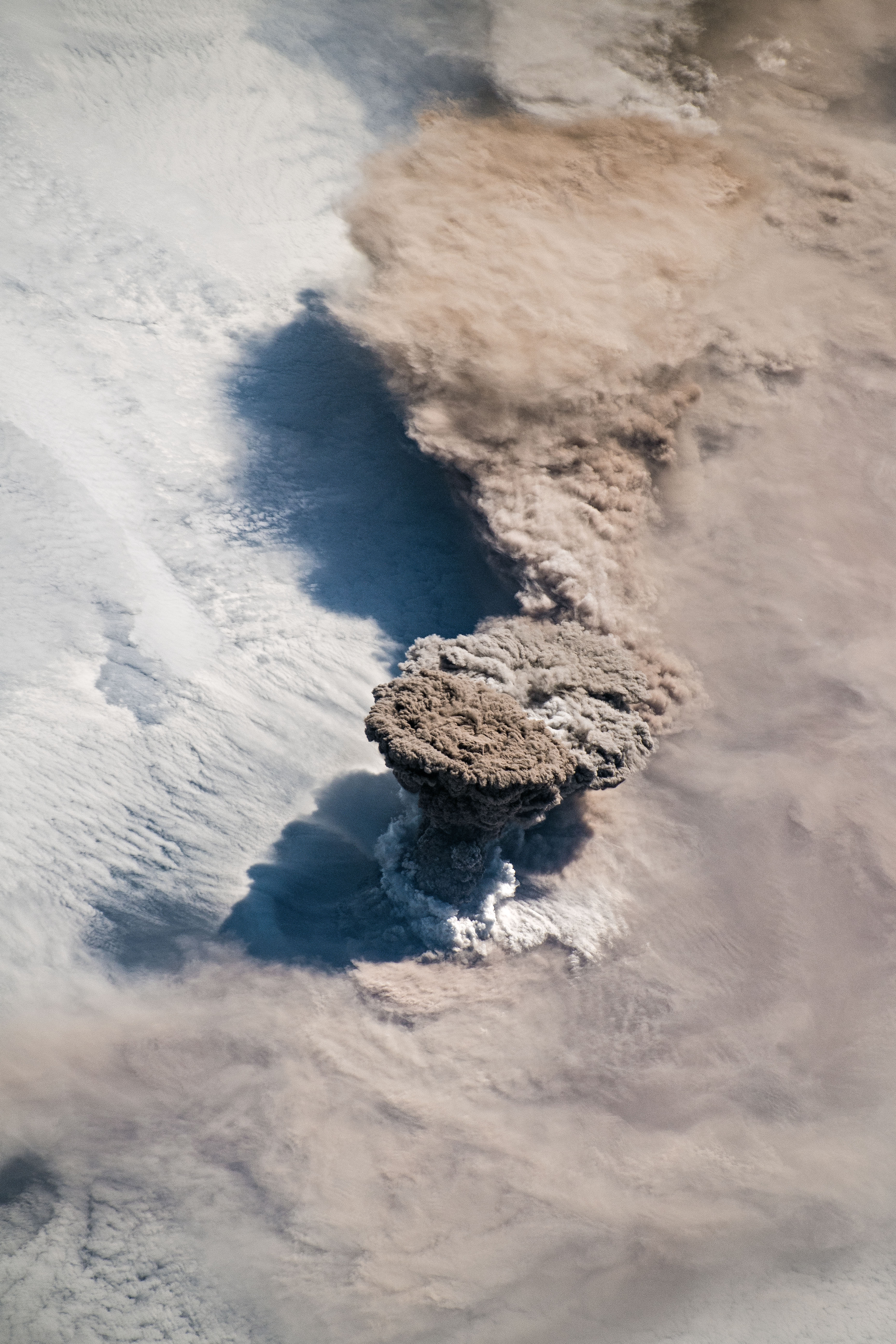
Raikoke volcano on the Kuril Islands in the north Pacific Ocean erupts. Situated off the coast of Russia just north of Hokkaido, Japan, the volcano erupted on June 22, 2019, for the first time since 1924. A column of ash, shaped like a mushroom, shot upwards from the mouth of the volcano’s 2,300-foot-wide crater. Click image to enlarge and zoom in. Image credit: NASA Earth Observatory/Joshua Stevens
A sociologist and English major by degree, I've worked in the area of civil society & human rights and have been blogging in the fields of travel, nature & science for over 20 years.
Check out my other project (especially if you're planning to visit Budapest soon) 👇





 Donate


Related Posts
The Best View of the Distant Universe Ever Captured Shows Galaxies From Over 13 Billion Years Ago
Mesmerizing Timelapse Reveals Jupiter’s Cloud Belts Moving at Different Speeds and Directions
First Images from Titan: The Only Photos Ever Taken from the Surface of Another Moon
Island in an Island: Krenitsyna Volcano’s Unusual Geography and Amazing Symmetry
Mount Erebus of Antarctica Rains Tiny Gold Particles—The Only Volcano Known to Do So
What’s at the Bottom? Going Deep Down in the Amazing World of Sinkholes
What Is This Strange Square on Mars Everybody’s Talking About, and Are There Other Man-Made Looking Structures?
Macquarie Island: The Only Place Where You Can See Earth’s Mantle Actively Exposed Above Sea Level
The Himalayas from Space: Stunning Views of Earth’s Tallest Peaks Like You’ve Never Seen Before
Chirstmas Tree and Christmas Lights: NASA Space Telescopes Show What the Festive Season Looks Like in Space